Airdrie Alberta Canada 2009 Centennial Year VIRTUAL TOUR of the Early Airdrie Townsite
See the early years of Airdrie in 3D with historical photos.
New to GoogleEarth? Check their video tour.
Disclaimers
We did our best. The digital town is an artist's impression from sparce photos of the early years - a kind of composite sketch, not to be taken as historical fact and not accurate geographically.
Credits
Doug Sanden - 3D artist and advanced media specialist
Historical sub-committee of the Airdrie Centennial Committee: Anna Rebus (historian and champion of the virttual tour project), Glen Hutchings, Elaine McCracken (field reconnaisance and building histories), Sharon Bilben, Dan McKinnon, Pat Jeffray, Dan Melody
Glenda Neufeld - project approval
All those who kindly offered their personal collection of photos for use in the Centennial projects used here for the virtual tour: Heloise Lorimer, Neil Ellison, Janet Loveday Mason, Marilyn McCall, and others - see credits in the scene.
Institutional sources of photos: Heritage Park, Nose Creek Valley Museum, Glenbow Museum
Jesse Burton, technology guru, City of Airdrie - recommendations on deployment format and technologies, web deployment
Staff and volunteers at Nose Creek Valley Museum: Laurie Harvey (curator), Mary Hickley, Karen Copley - archives and historical insight
Copyrights
Each photo carries its own copyright. Some historical photos have copyrights expired, some have authors unknown and we've primarily credited copy sources with "Courtesy: _____" burned in the photo.
The copyright on 3D buildings City of Airdrie or the artist.
Instructions
1. download and install googleEarth by following the link below if you don't have it installed already
Media Player: Google EarthTM (free version, all platforms)
2. download the Virtual Tour by clicking on the Airdrie Early Years Virtual Tour content link below
Content:  Airdrie Early Years Virtual Tour
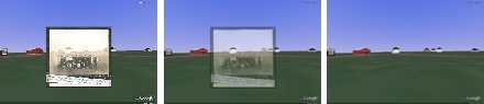
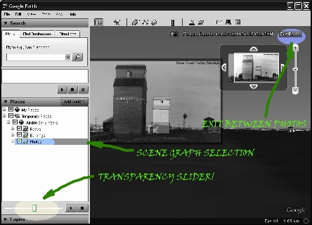
3. in GoogleEarthTM 3D view double click on a photo icon  to swoop
in
to swoop
in
4. use the transparency slider (slidebar control) to see the buildings behind the photo. Hint: make sure just the photo is selected in the scene graph. The slider can also make the buildings disappear when they are selected.
Google EarthTM is a trademark of Google Inc.